

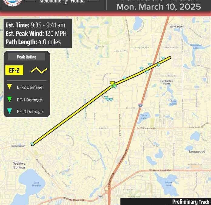
3/12/25 | The final report on Monday’s Seminole County EF-2 tornado has been completed by the National Weather Service. The tornado traveled for approximately 4 miles between 9:35 and 9:41 AM, with peak estimated winds of 120 mph.
Public Information Statement:
National Weather Service Melbourne FL
338 PM EDT Wed Mar 12 2025
…NWS Damage Survey for Seminole County Tornado Event…
Wekiwa Springs, Longwood, and Lake Mary Tornado…
Rating: EF-2
Estimated Peak Wind: 110-120 mph
Path Length /statute/: 4.0 miles
Path Width /maximum/: 300 yards
Fatalities: 0
Injuries: 0
Start Date: 03/10/2025
Start Time: 9:35 AM EDT
Start Location: Wekiwa Springs / Seminole County / FL
Start Lat/Lon: 28.7072 / -81.4204
End Date: 03/10/2025
End Time: 9:41 AM EDT
End Location: Lake Mary / Seminole County / FL
End Lat/Lon: 28.7385 / -81.3639
The National Weather Service in Melbourne confirms a tornado impacted portions of Seminole County on Monday, March 10, 2025.
The circulation touched down at approximately 9:35 AM EDT near the southeastern edge of Wekiwa Springs State Park where it produced
mainly vegetative damage in the form of downed oak and pine trees
from winds of 65 to 75 mph. The tornado continued on a northeast
trajectory where it crossed a wooded area of the state park and
into the Wingfield Reserve subdivision of Longwood. Here, more
trees were downed in the vicinity of Alvarado Ct and Wingfield Dr
due to winds of 80 to 85 mph. Several homes within the subdivision
experienced damage to their screened patios and pool enclosures.
The tornado intensified as it moved into the Whispering Winds
subdivision, bringing mostly winds of EF-1 intensity or up to 100
mph, leading to a significant number of trees that were downed or
snapped. More substantial residential damage was noted here,
particularly near the intersection of Misty Morn Pl and Blue Iris
Pl. Several homes had blown out windows, damage to garage doors,
as well as the loss of part of their roofs and awnings. The
tornado produced estimated winds of up to 120 mph, or EF-2
intensity, in a small area off of Blue Iris Pl, where the near
total collapse of a two-story wood framed home occurred.
The circulation dropped back to EF-1 intensity after crossing
Markham Woods Rd and into the Markham Glen and Mandaris Estates
subdivisions. Here, mainly tree and screen enclosure damage was
noted from estimated winds of up to 90 mph. Finally, the tornado
crossed Interstate 4 into Lake Mary, where it intersected a local
news station and several commercial structures before dissipating
at around 9:41 AM EDT.
There are no known direct injuries or fatalities as a result of
the tornado. The National Weather Service in Melbourne would like
to thank Seminole County Emergency Management, Orlando broadcast
media, trained spotters, and residents for providing information
before, during, and after the storm survey.
&&
EF Scale: The Enhanced Fujita Scale classifies tornadoes into the
following categories:
EF0…..65 to 85 mph
EF1…..86 to 110 mph
EF2…..111 to 135 mph
EF3…..136 to 165 mph
EF4…..166 to 200 mph
EF5…..>200 mph

NOTE:
The information in this statement is preliminary and subject to
change pending final review of the event and publication in NWS
Storm Data.
The post National Weather Service Provides Final Report on Seminole County Tornado first appeared on Winter Haven Daily.